Widespread strong to severe thunderstorm activity is forecast to take place ahead of a surface cold front and very strong middle-level weather system on Tuesday afternoon, evening and into Tuesday night.
The primary threat area extends from the southern Plains into the middle Mississippi Valley, with the primary threat being damaging wind gusts.
The latest severe weather outlook from the Storm Prediction Center (SPC) for Tuesday and Tuesday night is shown below:

Severe thunderstorms are possible anywhere within the brown shaded area, with the most likely threat of severe weather within the yellow and red shaded areas.
You've no doubt seen social media and even some commercial media boasting headlines of "Tornado Outbreak..." or something similar when referring to this event. As I've said all along here on the blog, I do not see this as being a tornado-driven event. The primary threat here will be damaging wind gusts, which could be widespread and intense in some areas.
I know tornadoes are more "glamorous" than wind damage, but keep in mind that a significant swath (or swaths) of wind damage can cause just as many (if not more) problems as a tornado, and the situation should not be taken lightly. Now with all of that said, I am by no means trying to suggest that there will be no tornado activity of any kind tomorrow afternoon or evening. What I am saying is that the dominant mode of severe weather is not likely to be tornadic. There will still be a risk of a tornado, but not a widespread or significant threat.
One of the "issues" for tornado development with this system is the fact that the winds will be blowing from virtually the same direction from near the surface up through the middle of the atmosphere. This does not allow for the vigorous rotation that we typically see with "tornadic supercells", which require a strong veering of wind direction with height.

Typical wind profile near a supercell thunderstorm
We will, however, have very strong speed shear in place from the surface and above, which will promote a widespread wind damage threat.
In this type of situation there are two typical tornado threats:
(1). with isolated storms that form out ahead of the main line
(2). within the rotating "comma head" of a bow echo or other line segment
Tornadoes in this type of scenario are typically "weaker" and last for a significantly shorter period of time than their supercell counterparts. With that said, a tornado is a tornado, especially if it's hitting your home or business. Because tornadoes typically have a shorter lifetime in this type of situation, they are also more difficult to warn on based on radar scans that only take place every 4-6 minutes.
Another thing to watch for, which could locally enhance tornado potential, would be any areas where the surface winds turn more toward the South or Southeast immediately ahead of the front. At this time, the most likely area for such a scenario will be within the red shaded area on the image at the top of the post, and perhaps extending back to the South/Southwest a bit further in Texas. This would enhance the steering profile and could result in a locally higher threat of a tornado. We'll have to watch closely for such developments as the actual event unfolds.
With the wind damage threat being significant on Tuesday afternoon and evening anyway, if a severe thunderstorm threatens your area and you have any doubt about what is happening, take shelter just like you would for a tornado just to be safe.
Thunderstorms are forecast to develop along and ahead of a cold front by late Tuesday afternoon from portions of central Texas into Missouri. The latest high resolution NAM computer model radar forecast below is valid at 6pm CST:

As you can see, the model is also forecasting a nearly solid line, with little to no isolated cells, even in Texas where the atmosphere will be slightly more supportive of such development.
Here are the radar projections of the same model for 9pm CST Tuesday:

...and Midnight CST, as the activity continues to progress toward the East:

Very heavy rainfall will also take place in association with the activity, all the way up into the Midwest and Ohio Valley, where widespread 2-4 inch amounts will be likely through 6am CST on Wednesday:

If you live in the severe weather threat areas for Tuesday, please be sure to pay attention to the weather. Listen to NOAA Weather Radio, local media or another trusted source for the latest watch and warning information. Be sure to identify your best sheltering location at home, work or school, and be prepared to move there quickly if threatening weather is observed or a warning is issued.
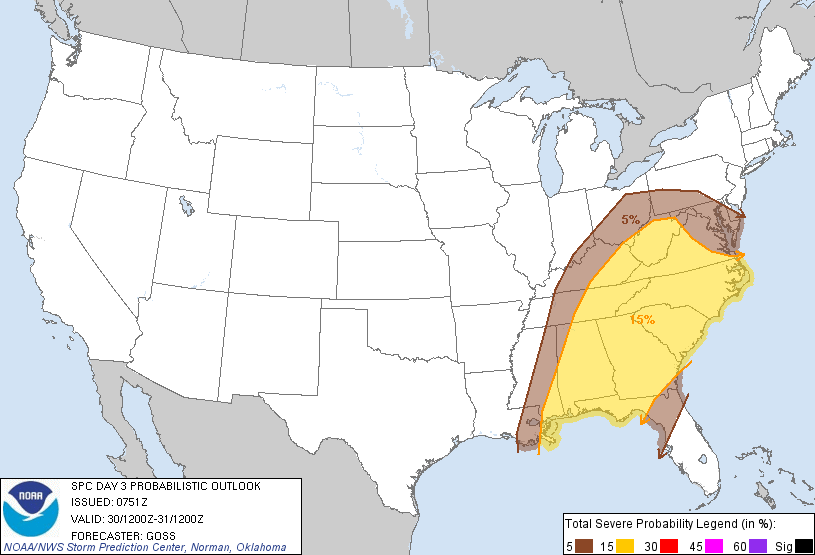
The threat of severe weather will shift Eastward into the southeast U.S. and mid-Atlantic region on Wednesday:
Stay tuned here on the blog for updates on the severe weather threats for both Tuesday and Wednesday...
For more information from 'The Original Weather Blog', including shorter, more frequent posts during rapidly changing weather events, please be sure to follow me on facebook and twitter:


Coming March 2013: The Tornado Chronicles full website!
• Interactive tornado database back to 1950 (earlier years coming soon)
• Interactive radar with live warnings and street-level zoom
• Tornado safety, preparedness and education
• Daily tornado outlooks/threat index
• Photos, videos & more!
1 comment:
It appears as though the spc forecast favors no severe threat as of now for the portions of srn/ctrl texas. The threat area has shifted farther northeast as of yesterday, im really believing theres going to be a severe weather outbreak, the chance of severe weather i think will be a very low probability in central tx. so im not too worried about central texas , therefore i believe that there is not any favorable threat in central tx as of now. though favorable for strong storms and possibly hail.
Post a Comment