It looks like the two major U.S. computer forecast models decided to get together in the spirit of Christmas and come into better agreement as to the exact track of the surface low pressure system for the Christmas Day snowstorm. This will generally make it easier to convey our expectations with greater confidence, especially as to what the storm will likely do to the East and Northeast of Oklahoma later on Christmas Day and into the Wednesday and Thursday time period.
Of course, keep in mind there is still time for the track of the system to change, which could have a dramatic affect on the outcome, but confidence is generally increasing in the follow scenario...
It still appears this morning as though the axis of heaviest snow will begin in west-central Oklahoma early on Christmas Day, and progress Eastward along and to either side of I-40 during the day. It still looks to me like the heavier snow will extend further North of I-40 than to the South, although some heavier accumulating snow will still likely fall as many as 30-50 miles to the South of I-40 as well.
The latest snow depth forecast from the high resolution NAM computer model is shown below and I generally find myself in agreement with it - as far as the general locations of accumulating snow are concerned. The exact amounts of snow are still up for debate...
The first image is valid at 12 Noon CST on Christmas Day:

...the next forecast image is valid 6 hours later, at 6pm CST on Christmas Day:

...and here is the forecast image valid at 12 Midnight late on Christmas Day:

As you can see, the NAM is very aggressive with the amount of snowfall, forecasting well in excess of 1 foot of snow from portions of central Oklahoma Eastward into west-central and northwestern Arkansas.
While the GFS model is in general agreement with the NAM as far as the expected axis of accumulating snow, it is lighter with respect to the intensity. The GFS model forecasts valid at each of the same times as the NAM are shown below:
GFS Model forecast valid at 12 Noon CST on Christmas Day (being a lower resolution model than the NAM, I can't zoom in as tightly, so please forgive the wider view, but clicking the image to enlarge may help a bit):

...and now the GFS forecast valid at 6pm CST on Christmas Day:

...and at 12 Midnight CST late on Christmas Day:

As you can see, the GFS agrees with the axis of heavier snow, but is quite a bit lighter with respect to accumulation (as compared to the NAM model), generally forecasting a 6-12 inch maximum across portions of west-central and central Oklahoma, and 3-6 inches across east-central Oklahoma into northwest and west-central Arkansas.
As I've been pointing out for a few days now, the exact track (with respect to location and speed) of the surface low will hold the key in determining the final outcome of this event, but looking at a blend of computer model data can give us a good idea as to the most likely scenarios.
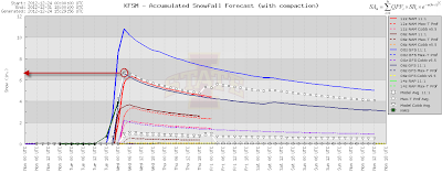
Lets take a look at the snow depth forecast graphs that I've been showing for the last few days for Tulsa, OKC and Ft. Smith. Here is the latest output below. I've circled the "average" forecast of all of the models in red, and drawn a red line to the left to show the average output in inches. The first graph is for Tulsa:

If you look closely (click the graph to enlarge), you can see that the model average is 6 inches, with a maximum of around 11 inches (yellow dashed line) and a minimum of around 1 inch (smaller dashed blue line).
Here is the same output for Oklahoma City:

Here again we have a model average forecast of 6.0 inches, with a maximum of 8.5 inches and a minimum of just under 2 inches.
Taking a look at the output for Ft. Smith, we have a model average of around 7 inches, with a maximum of 11 inches and a minimum of 2 inches:

Not to bombard you with data, but the event has now come into view of several of the shorter range, high resolution computer models as well. They also produce snow forecast output, and I thought it would be interesting to compare the data from above.
First, here is the output for Tulsa again (the format is a little different, but again I've circled the model average in red and drawn and arrow to the left to show the resulting amount of snow):

Here we have a forecast of about 7 inches, on average, for Tulsa, which is 1 inch higher than the average of the "major" models shown above.
Below is the same output for OKC, which results in an average forecast of near 5 inches, or just slightly below the "major" computer model composite results shown earlier:

...and last but not least, the output for Ft. Smith:

In this case, we have an average of around 3 inches forecast for Ft. Smith, which is quite a bit less than the average of the other models shown above.
For arguments sake, if we take the "average of the averages" from both the major computer models and the shorter range models, we would have a result of 6.5 inches for Tulsa, 5.5 inches for OKC and 5.0 inches for Ft. Smith.
It will certainly be interesting to see exactly how this comes out. The bottom line is that a lot of folks from Oklahoma into Arkansas will be happy to receive snow on Christmas Day. My congratulations and wishes of enjoyment to them!
With the joyous part of the forecast laid out, I would be remiss if I didn't play scrooge a little bit and point out that this will be a dangerous situation for some as well. The combination of heavy snow and strong, gusty surface winds will produce very dangerous conditions within the axis of heaviest snow. Power outages will also be a distinct possibility. So, please be prepared and make sure that you have your severe weather safety kit fully stocked. If you have travel plans that will bring you into the region today, I would suggest packing some extra clothing and supplies just in case you are stranded at grandma's for longer than you expected.
Winter Storm Warnings have been issued for the areas shown in pink on the image below, which includes the OKC Metro, Tulsa Metro and Ft. Smith as well as Fayetteville areas. Winter Storm Watches are in effect ahead of the storm in blue:

Speaking of "ahead of the storm", folks on to the Northeast across the Midwest and Ohio Valley will be affected by this storm from Wednesday into Thursday, as indicated by the Winter Storm Watch areas shown above.
The latest high resolution computer model output is forecasting heavy snow to continue in a band extending across southeastern Missouri, southern Illinois, central and southern Indiana into the central and northern two thirds of Ohio on Christmas night and into Wednesday. The image below is valid 6pm CST / 7pm EST on Wednesday evening:

Here in these areas as well, the combination of strong, gusty winds and heavy snow will create very hazardous conditions as well as the threat of power outages on Tuesday night and Wednesday. Please be prepared if you live in these areas...
Well, that about sums it up for now. At this point I don't anticipate another detailed, full post on what is forecast for Christmas Day, as we'll most likely be moving into the mode of reporting on what is actually happening as the event unfolds later tonight and tomorrow. If there are any significant changes in computer model data during the day today, I will post an update. Be sure to follow me on twitter, facebook and Google+ for shorter updates there as well. I also often post real time photos of the weather as it is happening on those sources as well...
For more information from 'The Original Weather Blog', including shorter, more frequent posts during rapidly changing weather events, please be sure to follow me on facebook and twitter:
If you are in need of highly customized, site specific weather forecasts and/or storm warnings for your business, school or event, be sure visit my professional webpage at WeatherGuidance.com.
No comments:
Post a Comment