Overturned vehicle near Garden City, KS
As expected, some very impressive snowfall totals came in overnight and early this morning out across the Plains. The image below shows an estimation of snow depth from the satellite perspective, valid 6am CST this morning:
The darkest blue shading extending from southeast Colorado across southwest Kansas, part of the Oklahoma panhandle and far northeast Colorado indicates 4-10 inches of snow by the satellite's estimation, but there are locally heavier amounts to be sure.
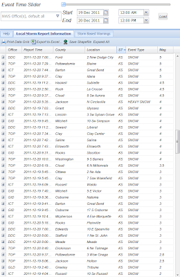
Below are some specific storm reports of snow depth this morning. They are organized from highest to lowest and by state. The snow depth in inches is on the far right hand column (so for example, on the 1st chart below, 20 inches of snow was observed 1 mile West of Walsh, CO). You can click on each table image to enlarge it.
Let's start with Colorado, which has the overall "winner" so far, with 20 inches reported near Walsh (far southeast corner of the state, near the Kansas border):
In Kansas, the trophy so far goes to a point near Scott City, with 15 inches:
Here is a video of the blizzard s it was underway in Garden City on Monday (which ended up with 7 inches officially):
The most observed in Oklahoma so far is 10 inches at Kenton, which is near the intersection of the Texas, Oklahoma, New Mexico and Colorado borders. Reported totals for New Mexico are at the bottom of the same chart, with a maximum of 6.5 inches reported at Cloudcroft:
...and finally the great state of Texas, with a maximum of 6 inches reported near Texline in Dallam County:
The storm is winding down now to be sure, but is not completely over. As you can see on the latest radar mosaic image below, areal coverage and intensity of the snow is decreasing, but light to moderate snow continues in several bands from Kansas across northwest Missouri, southern Iowa and southeast Nebraska at this hour:
Travel remains extremely hazardous across western Kansas and eastern Colorado, with most major roads closed. Please avoid venturing out in these areas at least through tonight. Blowing and drifting snow will continue for several hours even after the falling snow has come to an end, which will create further hazards.
If you enjoy reading 'The Original Weather Blog', please be sure to "like" our facebook page!


No comments:
Post a Comment