Conditions are continuing to come together for what looks to be a significant winter weather event, including locally heavy snow, across much of the Northeast on Saturday.
Below is an image showing the latest Watches, Warnings and Advisories that are in effect across the region from the National Weather Service:


 ...and then from 8am-2pm EDT Saturday:


Below is an image showing the latest Watches, Warnings and Advisories that are in effect across the region from the National Weather Service:

The next series of images show the same Watch/Warning and Advisory map, but zoomed-in on specific Metropolitan areas across the region. First, the Baltimore/Washington area:

...the Philadelphia area:

...the New York City area:

...and the Boston area:

The latest visible satellite image shows middle and upper-level energy "punching" Northeastward toward the Mid-Atlantic region:

As a result of this rapid increase in uplift across the region, low pressure is forecast to develop at the surface level off of the Carolina Coast later tonight, as shown in the latest GFS model forecast image valid 5am EDT Saturday morning:

This low pressure center will rapidly strengthen, as shown in the GFS model forecast images valid at 8am EDT on Saturday:

...and even more so by 2pm EDT Saturday:

...and 8pm EDT Saturday:

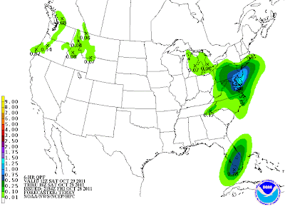
Precipitation is already breaking out across the region at this hour, and will increase rapidly late tonight and early Saturday, initially beginning as rain, as shown on the latest HPC rainfall forecast images below.
The first image is valid from 8pm to 2am EDT this evening and very early Saturday morning:

...then from 2am to 8am EDT Saturday:

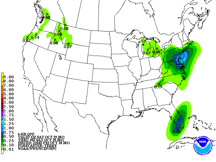
...and finally from 2pm-8pm EDT on Saturday:

Cold air will start to be drawn into the system from the North and Northwest by Saturday afternoon and evening, resulting in a changeover to snow across much of the region.
Snowfall is forecast to become heavy from interior Pennsylvania and New York into western New England, with localized amounts over 1 foot possible, especially in the higher elevations.
Before all is said and done early on Sunday morning, this is how I expect the snowfall totals to look, based on current data and trends:

Again, localized amounts of a foot or more are certainly not out of the question in the darker blue areas on the image above.
Complicating matters more will be the heavy, wet nature of the snow, along with strong, gusty winds, which will wreak havoc on trees and power lines across much of the region, much like what happened in the Denver area earlier this week (only potentially worse in the Northeast on Saturday due to stronger winds with this event):


Based on the current forecast trends, I suspect that both New York City and Boston will break their October maximum snowfall records of 0.8 and 1.1 inches, respectively. The record in the Baltimore/Washington areas of 2.5 and 2.2 inches will be harder to break, but is certainly a possibility.
The above forecast is based on current data, trends and observations. Heavier snowfall in this type of situation can be extremely localized, and we'll have an even better idea tomorrow than we do right now as to exactly how this will unfold, but the above will hopefully give readers in this region a good start.
Please check back to the blog for updates during the day Saturday. This post will not be updated, but rather new posts will be initiated, so please check the homepage of the blog or the "10 Most Recent Posts" link on the right hand side of the page.
If you enjoy reading 'The Original Weather Blog', please be sure to "like" our facebook page!
No comments:
Post a Comment