As expected, Invest 95 was absorbed by the frontal boundary near Florida early this morning. Shower and thunderstorm activity is breaking out all along the front and ahead of a developing upper level storm system from New England back into the mid-Atlantic coast, while heavy rains still linger across far Southern portions of Florida.
As upper-level energy increases across the frontal boundary today and tonight, low pressure will strengthen across the Ohio Valley and Delmarva region, with the GFS model depicting strong S-SW winds of 60-70 mph offshore from North Carolina to near Cape Cod by this evening (image valid 8pm EDT this evening shown below):

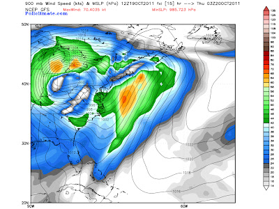


As upper-level energy increases across the frontal boundary today and tonight, low pressure will strengthen across the Ohio Valley and Delmarva region, with the GFS model depicting strong S-SW winds of 60-70 mph offshore from North Carolina to near Cape Cod by this evening (image valid 8pm EDT this evening shown below):

Further inland, strong winds of 30-40 mph with gusts to 50 mph can be expected by this evening from parts of the Carolinas on up into New England, as indicated on the same image (blue shaded and white shaded areas).
An even greater wind threat will be developing further West this evening, specifically across the Chicago area and much of Michigan, where sustained winds of 40-50 mph with gusts above 60 mph will be possible (image below is GFS forecast valid 10pm CDT this evening):
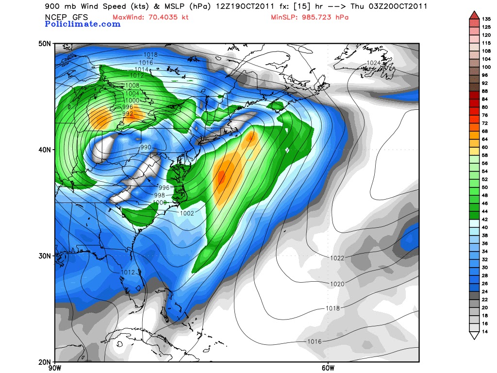
Note the stronger winds developing over Michigan, particularly the brighter orange shaded areas, which represent the models estimate of 60+ mph winds near the surface.
The strong winds will blow almost directly North to South along the entire length of Lake Michigan, which will push water up along and into the Southern shores of the lake, including the Chicago area and adjacent portions of Indiana. This, along with high wave action (perhaps on the order of 20 feet or more), will produce a significant threat of lakeshore flooding by this evening and into tonight.
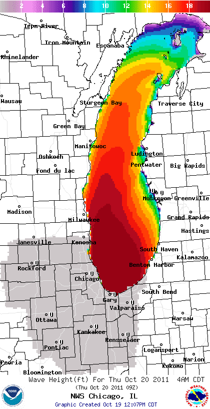
The image above from the NWS in Chicago's website indicates a forecast of widespread 18+ foot waves along the Illinois and Indiana shores of Lake Michigan by 4am CDT Thursday. The winds are likely to crank up starting around 3 or 4 o'clock this afternoon and continue to increase into the evening and overnight hours.
***Update 4pm CDT:
The photo below was just posted on Tom Skilling's facebook page by Corey Wojtkiewicz, showing the waves starting to get rockin' along the lakeshore in Chicago:

Winds at both Midway and O'Hare airports are currently averaging 20-25 mph sustained, with gusts of 35-40 mph. This is only the beginning, as winds will become even stronger later this evening and into tonight.
Watch for an update (via a new post thread) later this afternoon or early evening...
If you enjoy reading 'The Original Weather Blog', please be sure to "like" our facebook page!
No comments:
Post a Comment