
Moderate to heavy rain is widespread across far southern Florida this afternoon, as "Invest 95" spreads copious amounts of tropical moisture Eastward into the "Sunshine State." Today is only a preview, as the main show is still to come Tuesday into Wednesday for Florida, and Wednesday into Friday for the remainder of the Eastern Seaboard...
The latest visible and infrared satellite images of Invest 95 are shown below:


I've noted the center of circulation associated with the system at the tip of the yellow arrow on the visible satellite image. The yellow circle on the same image shows where moderate to heavy thunderstorm activity is currently concentrated. As you can see, the heavier activity (which also corresponds with the strongest winds) is still well removed from the center, which is one of the reason's the system has not been named thus far by the National Hurricane Center.
Regardless as to whether or not the system becomes named before striking Florida, its affects will be felt, both in the rain and the wind departments. Below is the latest forecast for rainfall from the HPC for the period 8pm EDT today through 8pm EDT Tuesday:
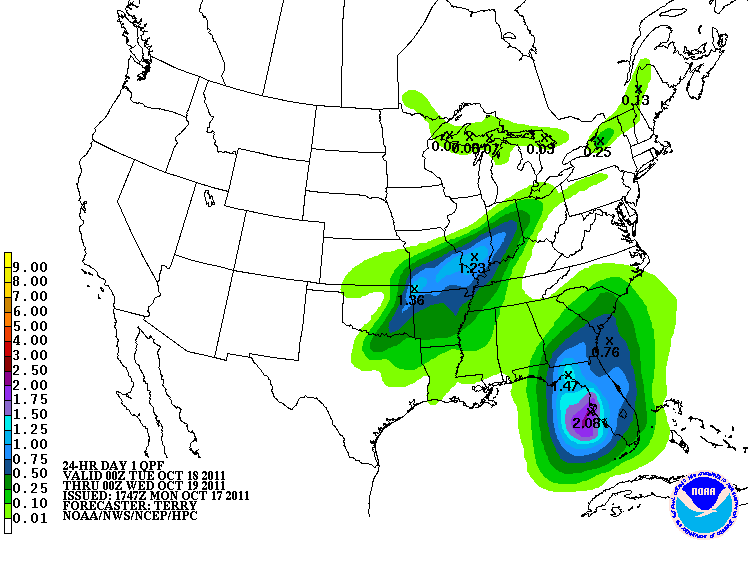
Localized amounts of 4-6 inches are possible during the same period of time, especially near the darker blue and purple shaded areas.
Sustained winds are forecast to increase into the 30-40 mph range, with gusts up to 60 mph possible across a large portion of the Florida peninsula during the day on Tuesday. The GFS computer model image valid 8pm EDT on Tuesday is shown below. The stronger winds (gusting to 50-60 mph) are indicated by the white and light orange shaded areas near the center of the state:

Sustained winds of 30-40 mph with gusts up to 50 mph are likely within the remainder of the green shaded areas across Florida (on the same image) during the day Tuesday.
The system is then forecast to lift Northward at an accelerated pace and become "extratropical" by the Wednesday through Friday timeframe. The winds will continue to crank up, with sustained levels of 80-85 mph indicated off of the North Carolina coast on the GFS computer model forecast valid 11am EDT on Wednesday (red and orange shaded areas on the image below):

By 8pm EDT on Wednesday, suistained winds of 90-95 mph are forecast by the model immediately offshore of the coast of Cape Cod:

During the same period of time, sustained winds of 30-40 mph with gusts up to 60 mph are likely to spread Northward along the coast from the Carolinas to New England on Wednesday, as well as a significant distance inland (as noted by the lighter blue and green shaded areas on the above forecast images).
Heavy rainfall will also become widespread during this time, with widespread amounts of 2-4 inches and local amounts of 6 inches plus along the seaboard from the Carolinas to southern New England:

So, regardless as to whether or not this system has a name during the next 24 hours, folks all along its path are in for a wet and windy time over the next 2-3 days. At into the mix a strong cold front, and some folks across the eastern Ohio Valley may also see some wind driven snow flakes late Wednesday into early Thursday morning.
If you enjoy reading 'The Original Weather Blog', please be sure to "like" our facebook page!
No comments:
Post a Comment